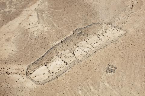
LATITUDE: 30°48'14"N / LONGITUDE: 34°46'19"E, October 9, 2011. Ancient walled farm, previously believed to be Nabataean but probably Byzantine (fifth century AD). The farm is made up of agricultural terraces within the bed of a seasonal stream. Ancient agriculture in the Negev, as well as the Bedouin agriculture that evolved from it, are based on the principle of “runoff irrigation.” Small terraces act as dams that channel and collect floodwater into irrigation basins. The water sinks deep into the soil and is stored there, rising to the surface over a long period. In an area with less than 100 millimeters per annum of rain, such irrigation systems could collect 4 times this amount and thus support cereal cultivation. There are thousands of kilometers of such terraced wadis in the Negev. The small protrusions of earth on the slope at top left are ancient tuleilat al-ʽēnab (Arabic, “grape mounds”). The structure at the lower right would have been used for dwelling and storage., from the series Desert Bloom
Artist: Fazal Sheikh (American, born 1965)
Technical metadata and APIs
- IIIF
-
The International Image Interoperability Framework, or IIIF, is an open standard for delivering high-quality, attributed digital objects online at scale. Visit iiif.io to learn more
- Linked Art
-
Linked Art is a Community working together to create a shared Model based on Linked Open Data to describe Art.