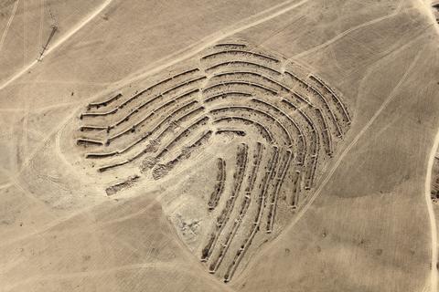
LATITUDE: 31°18'50"N / LONGITUDE: 34°40'58"E, October 4, 2011. Plantation work for the Ambassador Forest organized by the JNF, using the method of “savannization”: a mixture of sparsely scattered acacia or eucalyptus trees with bushes and grass between, as found in the savannah region. Irrigation comes from long terraces that collect rainwater, optimizing the water retention. The fields around the planted area are cultivated by Bedouins, and are distinguished by the shallow plowing or “scratching” technique of cultivation. The small spots within the field show where wheat was collected in previous years. The forest was planted atop the Bedouin village of Abu ʽAbdūn, of the Tiyāha tribe, evacuated and destroyed in the winter of 1948. The path, accompanied by a pair of shallow fences that run diagonally from lower left to top right through the center of the image, coincides with the planned route of a railway line, construction of which began in early 2012. The forested area has since been overridden., from the series Desert Bloom
Artist: Fazal Sheikh (American, born 1965)
Technical metadata and APIs
- IIIF
-
The International Image Interoperability Framework, or IIIF, is an open standard for delivering high-quality, attributed digital objects online at scale. Visit iiif.io to learn more
- Linked Art
-
Linked Art is a Community working together to create a shared Model based on Linked Open Data to describe Art.