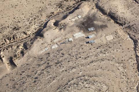
LATITUDE: 31°16'17"N / LONGITUDE: 34°59'48"E, November 22, 2011. Remains of the foundations of the homestead of Ḥasan a-Sarāyʽa, of the Abu Jwēʽid tribe, on the outskirts of the unrecognized village of Bāt al-Sarāyʽa. The buildings were recently demolished; debris littered about the site indicates a forced evacuation. The area is now considered a closed military live-fire training zone. Despite the evacuation, two small structures—whose tin sheeting is held down with rocks—have been reconstructed atop the remains. The height of the structures casts its shadow upon the land. The site is on the land of Shlalīn, a Bedouin community evacuated in the aftermath of Operation Yoʼav., from the series Desert Bloom
Artist: Fazal Sheikh (American, born 1965)
Technical metadata and APIs
- IIIF
-
The International Image Interoperability Framework, or IIIF, is an open standard for delivering high-quality, attributed digital objects online at scale. Visit iiif.io to learn more
- Linked Art
-
Linked Art is a Community working together to create a shared Model based on Linked Open Data to describe Art.