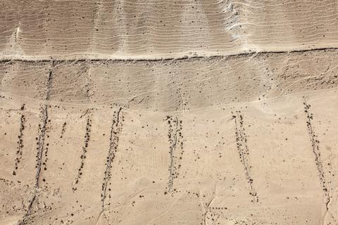
LATITUDE: 30°45'60"N / LONGITUDE: 34°47'31"E, October 9, 2011. Garden perimeter wall and irrigation channels along a steep ridge in the vicinity of the ancient city of Ovdat/Abdāt (Heb./Arabic). The upper line of rocks forms the outer wall of the garden and also serves as a footpath above which can be seen the faint trails left by Bedouin pastoral herds. Rainwater is channeled along the descending lines of rock to the garden within the streambed, each small walled section retaining its own water to minimize runoff. The faint lines that run parallel to the upper wall are traces left by herds of animals moving over the terrain. These walled gardens enhance water retention in an area of extremely low precipitation, as well as demarcating boundaries of ownership. This garden, measuring more than a kilometer in length and a quarter of that distance at its widest point, winds along the base of a hillside., from the series Desert Bloom
Artist: Fazal Sheikh (American, born 1965)
Technical metadata and APIs
- IIIF
-
The International Image Interoperability Framework, or IIIF, is an open standard for delivering high-quality, attributed digital objects online at scale. Visit iiif.io to learn more
- Linked Art
-
Linked Art is a Community working together to create a shared Model based on Linked Open Data to describe Art.